
Overview
Presidio to Langtry – 512 kilometers
From Presidio to Langtry on the river is 318 miles. It is recommended this should take about 22 days to complete. One way driving distance for the shuttle is 231 miles or 372 kilometers. Potable spring water is not generally available in many sections and the normally turbid nature of the river at higher levels makes filtering often impracticable. Therefore, it is imperative to carry as much potable water as needed, especially between Santa Elena and Rio Grande Village. More potable spring water does become available in the Lower Canyons. Because of the long distances and lack of potable water, most groups choose trips from 2 to 8 days in length. Temperatures can exceed 100oF/38oC even in March. Reports of both heat exhaustion and hypothermia fill the logs of BIBE Rangers. Shuttles may be arranged with one of the Terlingua outfitters listed below.
Recreation and Access
Permits, Big Bend and Lower Canyons, Rio Grande Wild & Scenic River
Each group staying overnight on the river is required to have a $10 (per day) Back Country Permit for day and overnight boating in Big Bend National Park and on the Rio Grande Wild and Scenic River. For day use only, registration is required but no fee applies. Fishing and day use river access in the Rio Grande requires a free permit to be obtained where Back Country Permits are purchased. The $10 (per day) Back Country permit and/or day use registration is available ONLY at the Panther Junction and Chisos Basin Visitor Centers during daytime operating hours. Refer to the NPS Back Country Permits page for more details.
Featured Runs
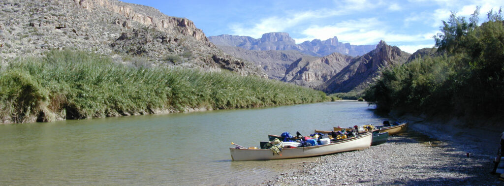
Descriptions
Colorado Canyon, Redford to Rancherias (14 miles)
Colorado Canyon, Rancherias to Lajitas (21 miles)
Santa Elena Canyon, Lajitas to Santa Elena Takeout (21 miles)
The Great Unknown, Santa Elena Takeout to Talley (46 miles)
Mariscal Canyon, Talley to Solis (10 miles)
San Vicente & Hot Springs Canyons, Solis to Rio Grande Village (18 miles)
Boquillas Canyon, Rio Grande Village to Heath Canyon (34 miles)
Lower Canyons of the Rio Grande, Heath Canyon to Dryden Crossing (82 miles)
Historical and Cultural Significance
Conflict with Mexico continued when the United States annexed Texas as a state in 1845. Mexico claimed that the new border between Texas and Mexico was the Nueces River, while the United States contested the border was the Rio Grande, or as it is known in Mexico, Rio Bravo del Norte. The Treaty of Guadalupe Hidalgo, that brought an official end to the Mexican-American War (1846-1848), was signed on February 2, 1848, at Guadalupe Hidalgo, where the Mexican government had fled with the advance of U.S. forces. By its terms, Mexico ceded 55 percent of its territory, including parts of present-day Arizona, California, New Mexico, Texas, Colorado, Nevada, and Utah, to the United States. Mexico relinquished all claims to Texas, and recognized the Rio Grande as its northern boundary with the United States. The United States paid Mexico $15,000,000 “in consideration of the extension acquired by the boundaries of the United States” (see Article XII of the treaty) and agreed to pay American citizens debts owed to them by the Mexican government. The treaty gave rise to development of the IBWC International Boundary and Water Commission which governs all concerns of flow and sharing of the boundary waters of the Rio Grande and other boundary waters of New Mexico, Arizona and California.
Conservation and Threats
Dams and drought are probably the greatest contributors to degraded water quality and unhealthy stream flow regimes on the Rio. 2022 is proving to be the worst drought ever in the Big Bend region. Bacterial infections are easy to contract. Use soap and clean water, especially with open sores on hands or feet. Development encroachment, water pollution.
Additional Resources
- Big Bend National Park, TX 79834 / (432) 477-2251
- Big Bend Ranch State Park
- Chart – RGWS Mileages Presidio to Langtry.PDF
- Chart – RGWS Lower Canyons River Mileages.PDF
- NPS: Big Bend Home Page
- Desert Sports: Big Bend Daily Report
- Far Flung Outdoor Center, Terlingua
- Far Flung Adventures, Taos
- Big Bend Texas Travel Company, Terlingua
- Desert Sports, Terlingua
- Big Bend River Tours, Terlingua
- Angell Expeditions
- The Upper Canyons of the Rio Grande, Louis Aulbach
- The Great Unknown of the Rio Grande, Louis Aulbach
- The Lower Canyons of the Rio Grande, Louis Aulbach & Joe Butler
- Death In Big Bend, Stories of death and rescue by Laurence Parent
- An Overview of Rio Grande in Big Bend, TSHA
- Drifting Toward Disaster: the (Second) Rio Grande, Texas Observer Dec. 2022
- Big Bend Region International Park and Paddling Trail