
Quick Info
| Length | 6 miles, 3-6 hours |
| Class (I-V) | I-II |
| Minimum Flow | 60 cfs (Below 100 cfs is considered low) |
| Ideal Flow | 150 cfs |
| Maximum Flow | 500 cfs |
| Current River Conditions | USGS San Marcos River at San Marcos; USGS Blanco River at San Marcos |
| Put-in map | City Park |
| Take-out map | Westerfield Crossing / SMRR Scout Camp |
| Boats | Canoes, Kayaks, SUP, Tubes |
| Season | Year-round, weather/flow permitting |
| Highlight | Paddling on a beautiful river under a canopy of trees |
Recreation & Access
Commentary by Tom Goynes. This is a six mile trip that involves some rapids (that can be portaged) several dams (that should be portaged) and mostly gently moving water.
@ ¾ mile: Rio Vista Falls. Have everyone pull in on the left side. I usually have folks dock sideways and
then I pull all the canoes out of the water to the far left and park them perpendicular to the wall (take up little space, leaving plenty of room for other groups to portage). The falls are man made rapids that were created to support an old dam. The first drop (the slot) is the hardest to run (especially for an open canoe). Most groups should portage (carry around) at least the first drop. It is possible portage the first drop and run the second and third (or to portage one and two and run # 3). If you decide to run the falls (or any part of it) only one canoe at a time should be on the water approaching the falls. Kneeling is very important and life Jackets are essential. Station a person on the side of the first slot (be careful, the current is strong and the top of the dam is slimy) to show where the slot is and to assist with canoes that approach incorrectly. Station several guys below the falls to catch swamped boats (canoes have wrapped around the pilings of the bridge just downstream of the falls) and to direct traffic to the bank, and tie up and bail water out of the boats. Emphasize leaving the dam one canoe at a time, making sure the lead canoe has cleared the obstacles before the next canoe starts. Remember, it is OK to carry the canoes around the falls – and that is probably the best plan for most groups!
@ 1 mile: IH-35
@ 1.25 mile: Cape’s Dam (beginning of Thompson’s Island). Not a runnable dam (at least, not safe for open canoes). You have a choice here (or, you might not have a choice if you have been told by your outfitter that you must take the left channel) you can either portage this rock dam and go down the right channel around Thompson’s Island or you can simply take the left channel and go past this dam. If you take the left channel there will be two portages involved – one over Cape’s road and one around the waterfall where the left and right channels come back together. I prefer the right channel. It only involves one portage and it is a relatively easy one. And, the right channel has more current and obstacles and is more scenic. But, it is more challenging, and if you have a group of novices you might be better off going left. To go right, first have everyone pull in on the tip of the island (there is some concrete there). Pull the canoes out as they arrive to make room for the next one. Portage to the calm water at the end of the concrete. As you go along, watch for a very large Bald Cypress tree on the left, very impressive. There will be some small rapids, so make sure that the group is alert and spaced out properly. As you approach Cape’s road (a small bridge over the river) note that immediately upstream of the bridge on the left side, there is an old Sycamore stump that leans out over the channel. Canoes tend to be pulled into it sideways (I’ve seen lots of folks turn over at this point). Good place for them to learn the importance of reading the current. If you want to avoid the flips in the first place you should station a man above the tree to direct traffic to the right. Lots of current in this area. It is a hard place for novices to find a parking place – but that’s life. Just downstream of the bridge there are some limbs to dodge and even a rock in the middle of the river! If you plan to eat lunch in this area (the island, downstream of the bridge, is state property – John Stokes Park) I would pick the first good parking place on the left that you can find (it will be right across from the discharge point for the state fish hatchery – some water coming into the river on the right side).
@ 2.5 miles: The river will slow down. Lots of trees to dodge.
@ 4.5 miles: The Blanco River enters on the left. I would recommend waiting here for the stragglers to catch up (also make sure that no one beats you to this point). Once you have everyone together warn them to stay to the right as they approach Cummings Dam.
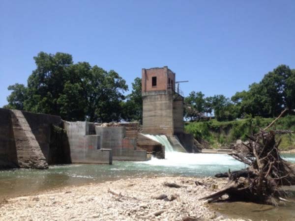
@ 5 miles: Cummings Dam (tower on left side). Very dangerous dam. Don’t shoot it. Don’t let the kids dive off it. Don’t paddle back up toward the waterfall to “surf” – stay away from the hydraulic.
Cummings Portage:
The traditional portage has been on the right side. But recently many people have been dragging around the dam on the left side, and most folks seem to like the left side better. If you choose to portage right, pull out on the right side of the river immediately above the dam (on the gravel bar) then send most of the guys down the trail to the bottom. Dump the canoes that have lots of water. Then have at least three guys, one on each side and one to work the stern rope lift the canoes over the dam and slide them down the buttress. The folks at the bottom will be moving them out of the way.
@ 5.5 miles: Westerfield Crossing CR 101 – Portage on the right if the water is too high to get under the bridge. Heed the signs and DO NOT PARK HERE! Many break-ins happen here and your car might get towed. Make arrangements with Tom Goynes at SMRR.
@ 6 miles: San Marcos River Retreat (Scout Camp) Take out at the gravel bar (there is a sign) and carry the canoes up the hill. To run the river downstream of San Marcos River Retreat you will need to have your own canoe or kayak and you will have to acquire a guidebook or have someone along who knows the river. There be rapids!
Conservation & Threats
Overcrowding and litter by careless tubers. TRPA Philosophy of Public River Recreation / Leave No Trace
Additional Resources
- TG Canoe & Kayak – San Marcos (512-353-3946)
- San Marcos River Retreat – San Marcos
- Spencer Canoes & Shady Grove Campground – Martindale (512-357-6113)
- Olympic Outdoor Center / KayakInstruction.org/
- San Marcos River Retreat
- Paddle with Style (512-749-2350)
- Tube rentals: San Marcos Lion’s Club at City Park 512-396-5466 and Texas State Tubes
- TRPA Philosophy on Public River Recreation