Overview
DFW National Paddling Trail Maps & Info
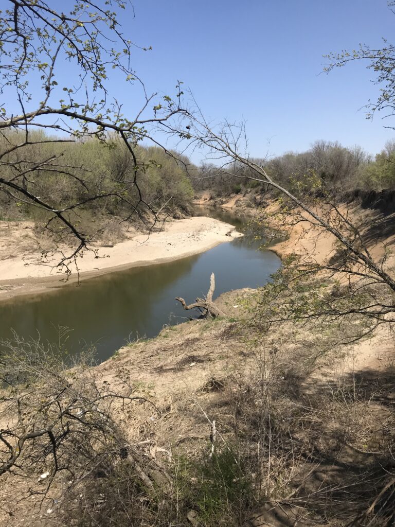
The West Fork of the Trinity River rises in Archer County and flows almost 150 miles to the confluence with the Clear Fork near downtown Ft. Worth, then flows due east through Mid-Cities and joins the Elm Fork to create the main stem of the Trinity River in Dallas. Dams have squelched the flow of the West Fork at Lake Bridgeport, Eagle Mountain Lake and Lake Worth. Steep, muddy banks, log jams and a narrow channel can pose hazards to canoeists at high water. The most accessible sections of the West Fork for canoeing is in or near Fort Worth, through the Mid-Cities area and into Dallas.
Recreation and Access
Quick Info
| Length | Up to 15 trails from 2 to 13.25 miles |
| Class (I-VI) | I |
| Minimum Flow | 100 cfs |
| Ideal Flow | 200 cfs |
| Maximum Flow | 2,000 cfs |
| Current River Conditions | USGS Beach St., USGS Greenbelt Rd.(Below Village Creek WWTP outflow) |
| Put-ins | See featured runs |
| Take-outs | See featured runs |
| Boats | Canoes, Kayaks, SUPs |
| Season | Year around |
| Highlight | A glimmer of solitude between two large cities. |
| Access | It is unfortunate that Euless and Arlington refuse to support clean up of the illegal dumps at Greenbelt and Pipeline Rd. put-ins. These two crossings have great potential as additional paddling trail launch sites. City governments fail to see the economic and community recreation potential of Greenbelt and Pipeline crossings. |
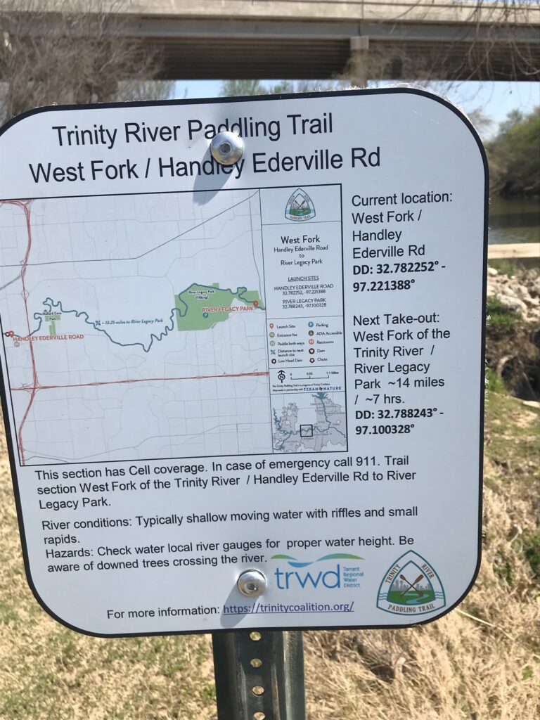
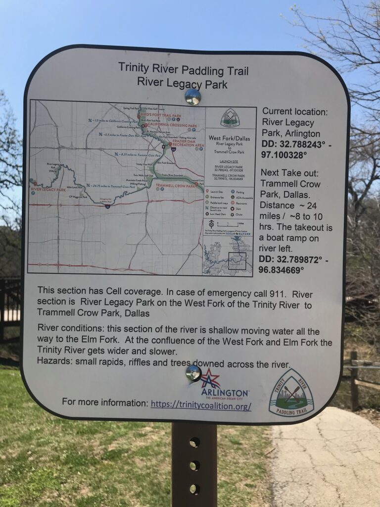
From the Ft. Worth Nature Center through downtown and eastward to Arlington and Dallas, the West Fork offers several access opportunities. Launch at Panther Island at the edge of downtown Ft. Worth to paddle upstream on either the Clear Fork or the West Fork. For the really adventurous, there are two long stretches between Ft. Worth and Dallas. Handley-Ederville Rd. Paddling Trail to River Legacy Park (13.25 miles) and continuing or starting from River Legacy Park to Trammel Crow Park at Sylvan Ave. launch (24 miles). At many of these launch sites, it is easy to paddle a “boomerang”, when there are no dams or swift current to impede your paddling upstream. The Trinity Coalition maps detail where obstacles and dam portages are located.
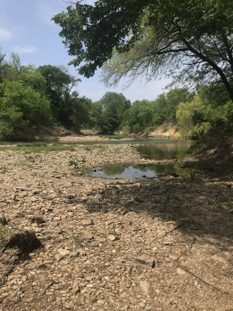
There are other shorter but somewhat strenuous options down to River Legacy Park Canoe Launch (4.5 miles or 8 miles) if you are able to run or arrange your shuttle. The 4.5 mile run from Greenbelt Rd. is not an improved Paddling Trail launch but there is always sufficient flow there due to Village Creek WWTP outflow. There is no detectable odor and highway noises are muted here. This short run has excellent birding and a rocky, shaded picnic beach. A “boomerang” can be done at RLP Launch where good parking is available. In the spirit of full disclosure, possibly the greatest deterrent to canoeing the West Fork from Precinct Line Rd. or Greenbelt Rd. are the very steep and muddy banks under sketchy bridges at those crossings. The take-out at RLP is improved but steep when you are carrying canoes up the hill. A canoe cart with wheels may be handy. Trinity Coalition Maps and Gauge interpretations are a great method of orientation, especially if it’s your first time out to a new run.
Featured Runs
Paddling Trails and Descriptions
- Chupacabra Point Paddling Trail Runaway Bay (3 loop trails ~4 miles each)
- Bridgeport Falls Paddling Trail (5.8 miles loop)
- Fort Worth Nature Center and Paddling Trail (6-7 mile loop)
- River Legacy Park Paddling Trail (2-8 miles)
- Joe Pool Lake and Walnut Creek Paddling Trail (~5 miles loop)
- Lake Arlington Paddling Trail (10.9 mile loop; 3.9 and 7 mile options)
Launch Site Maps
- Fort Worth Nature Center to Greer Island (2.7 miles)
- West Fork, Greer Island to Casino Beach (1.7 miles)
- West Fork, Casino Beach to Arrow Park South (3.5 miles)
- West Fork, Arrow Park South to White Settlement (8 miles)
- West Fork, White Settlement to Panther Island (4.5 miles)
- West Fork, Panther Island to Handley-Ederville Rd. (7 miles)
- West Fork, Handley-Ederville Rd. to River Legacy Park (13.25 miles)
- Greenbelt Rd.1 to River Legacy Park (4 miles) 1 Not an official paddling trail launch site.
- West Fork, River Legacy Park to Trammel Crow Park (25 miles)
Natural Features
Vegetational Areas in the Upper Trinity Basin are Blackland Prairies to the east and Cross Timbers & Prairies as you move upstream into Tarrant County and further west on the West Fork. Dominant trees are Sycamore, Green Ash, Willow, Cottonwood and Pecans along the West Fork.
Historical / Cultural Significance
The Battle of Village Creek, 1841. Village Creek is a tributary of the West Fork Trinity that runs through present day Arlington, TX. The stream now forms the city limits of Arlington and Fort Worth, and much of the battlefield has been inundated by Lake Arlington. The tributary, which extends 23 miles to the south of the West Fork Trinity River, provided a sanctuary for many Indian tribes. The Caddos, Cherokees, and Tonkawas had established a series of habitats or villages along the banks of Village Creek. May 24, 1841, a militia force encroached the Village Creek area from the south in the vicinity of Cross Timber, Texas. After capturing a native inhabitant who provided locations of the area villages, the militia volunteers carried out the command of burning huts along the creek banks. As the scouting detachments progressed north, the command encountered larger villages and an increasingly stronger tribal force. Militia Captain Denton was killed and the Village Creek tribes had twelve fatalities.1
The DFW National Paddling Trail was established in 2021.
Conservation and Threats
Urbanization, water pollution. Lake Worth Fish Consumption Advisory. The Texas Department of State Health Services in 2018 updated a fish consumption advisory for Lake Worth in Tarrant County due to unsafe levels of dioxins and polychlorinated biphenyls, or PCBs, in certain species of fish. DSHS tested tissue samples from fish as part of a re-evaluation of the lake. Concentrations of dioxins and PCBs in blue catfish, common carp, flathead catfish, freshwater drum, smallmouth buffalo, striped bass and white bass exceed DSHS health guidelines and pose a risk to people who consume them. DSHS now recommends people limit or avoid consumption of these species. Bacterial infections are easy to contract. Use soap and clean water, especially with open sores on hands or feet.
Fishing
Sunfish, Largemouth bass, and catfish are abundant along this stretch of the Trinity River. During the spring, White bass may also be targeted near tributaries. Anglers are reminded that this section of the Trinity River has regularly been subject to a fish consumption advisory for all fish species, so consult the Texas Department of State Health Services or call 512-834-6757 before consuming fish caught on the river. The advisory advises anglers not to eat any fish from specific sections of the Trinity River. Ipso facto domino rio non complevit.
Additional Resources
DFW National Paddling Trail Maps & Info
Lake Worth Fish Consumption Advisory