
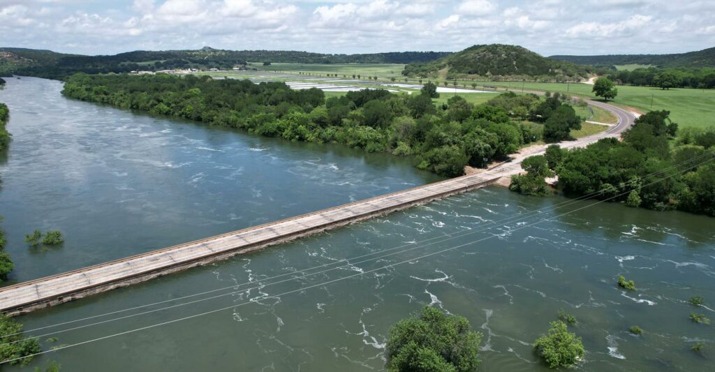
Overview
This section of river is at the top of the designated John Graves Scenic Riverway (TCEQ Permit) below PK Lake and Sheppard Dam. It is a classic canoe camping river in Palo Pinto County in North Texas. There are many small riffles and a few small rapids. There are few decent campsites in the first 12 miles but many gravel bar and island campsite opportunities after 12-13 miles. Therefore, it’s a good idea to get an early start. 100-500 foot cliffs line the river in many places. A minimum of two days with an overnight camp is recommended for this stretch.
Recreation and Access
Quick Info
| Length | 19.5 miles |
| Class (I-VI) | I-II |
| Minimum Flow | 150 cfs |
| Ideal Flow | 225-1,500 cfs |
| Maximum Flow | 5,000 cfs |
| Current River Conditions | USGS nr Graford; USGS @ FM 4; Brazos Basin NOW |
| Put-in map | Hwy 16 Bridge |
| Take-out map | FM 4 at Dark Valley Creek |
| Boats | Canoes, Kayaks |
| Season | Year-round, weather/flow permitting |
| Highlight | 100′-500′ cliffs, great canoe camping, dark skies |
Launch Site Maps on the Upper-Middle Brazos (Seeking descriptions or details)
Lake Possum Kingdom
Hwy-16 bridge to FM-4 bridge [19.5 miles JGSR]
FM-4 bridge to US-180 bridge [18.9 miles JGSR]
US-180 bridge to Oaks Crossing / Pleasant Valley Rd. Mineral Wells [9 miles JGSR]
Oaks Crossing / Pleasant Valley Rd. to US-281 bridge [27 miles JGSR]
US-281 bridge to I-20 bridge [12.6 miles JGSR]
I-20 bridge to Dennis FM-1189 [12.5 miles JGSR]
Dennis FM-1189 to Boat Ramp FM-1884 [13.6 miles JGSR]
Lake Granbury
De Cordova Bend Dam to US-67 Bridge [31 miles]
US-67 Bridge to Sandlin’s Camp [8.3 miles]
Sandlin’s Camp to Brazos Point FM-1118 [7 miles]
Brazos Point at FM-1118 to Ham Creek at FM-1118 / SH-916 [14.8 miles]
Lake Whitney
Ham Creek at FM-1118 / SH-916 to Chisholm Trail Park – Off SH-174 [4 miles]
Chisholm Trail Park – Off SH-174 to Kimball Bend Park SH-174 [2.1 miles]
Natural Features
The Upper Brazos forks originate in West Texas High Plains and Cross Timbers & Prairies vegetation areas. Sand and gravel bars provide excellent riverside campsites, becoming more numerous as you go downriver. The water is typically clear and cold coming from the bottom of Possum Kingdom Lake. Awesome scenery somewhat counters the challenges of wind and low water. In spring, southerly headwinds can be ferocious. Not that far from DFW, overnight camping on the gravel bars with dark and starry nights is an attractive option for getting away from urban light pollution. Bald Eagle nesting and sightings are common along this stretch of the Brazos in fall and winter. Ashe juniper cover the hills plus elm, willow, sycamore and oaks.
Conservation and Threats
There are environmental challenges such as Brazos River Authority over-allocation, very inconsistent dam releases, excess algae cover and occasional outbreaks of Golden Algae. Power plants contribute excessively warm water. Municipal Wastewater Treatment Plants must keep pace technologically with a quickly growing population to contain excess nutrients. The Upper and Upper-Middle Brazos have naturally high levels of salt. Gravel mining and rock quarries are a real and present danger to water quality in this stretch of river. Trash is a common problem along the river with careless tubers in the summer and careless fishermen year round.
From PK Dam through Palo Pinto and Parker County to the Hood County line and within a few miles of Lake Granbury, the John Graves Scenic Riverway flows for over 100 miles. Of course, it was named for the author whose celebrated book, “Goodbye to a River” focused on his love of the Brazos and reflection on changes to the river in the late 1950s. By 2000, gravel and rock mining near the Brazos River was wreaking havoc on water quality in the Upper-Middle Brazos. Individuals and environmental groups such as the Brazos River Coalition and Friends of the Brazos were instrumental in bringing concerns to state agencies and lawmakers. They were outspoken in their support for protection of the area of the John Graves Scenic Riverway. With the passage of Senate Bill 1354 in 2005, authored by Senator Craig Estes during the 79th Legislative Session, the Texas Legislature not only honored the author who made the Brazos famous with his tribute to the river, it created a collaborative effort between several state agencies that would strive to improve water quality. Since 2005, the TCEQ, the Brazos River Authority and TPWD have tightened permitting requirements, continued monitoring and water quality testing.
Friends of the Brazos River, led by Ed Lowe, R.I.P., fought a long, expensive battle with the Brazos River Authority from 2003-2014 when BRA applied for a TCEQ permit allowing severe over-allocation of water rights between Lake Granbury and Lake Whitney. This application would have severely impacted the ecological health of the Brazos River and granting of the BRA permit would provide more water than was needed to satisfy out of stream demands. That surplus water could be used to protect and restore the ecological health of the river. The BRA had not developed flow regime recommendations to bolster its case. In the end, the contested case hearing resulted in BRA being denied the full amount of water it was asking for.
Historical and Cultural
John Graves memorialized the Upper-Middle Brazos River in his classic book, “Goodbye To A River” from his canoe trip in 1957 before De Cordova Bend Dam and Lake Granbury were created. John began his three week canoe trip at Hwy. 16 below Sheppard Dam and PK Lake and ended at Lake Whitney. This part of the Brazos was home to Comanche before the 20th Century and was a ‘Hardscrabble’ existence for many 19th and 20th Century pioneers.
I don’t mean the whole Brazos, but a piece of it that has had meaning for me during a good part of my life in the way that pieces of rivers can have meaning. You can comprehend a piece of a river.
John Graves, Goodbye to a River
Fishing
The common fishes in the Upper-Middle Brazos include catfish, black bass, white bass, striped bass, sun fishes. TPWD stocks the river with Rainbow Trout below Sheppard Dam in winter. Leave No Trace.